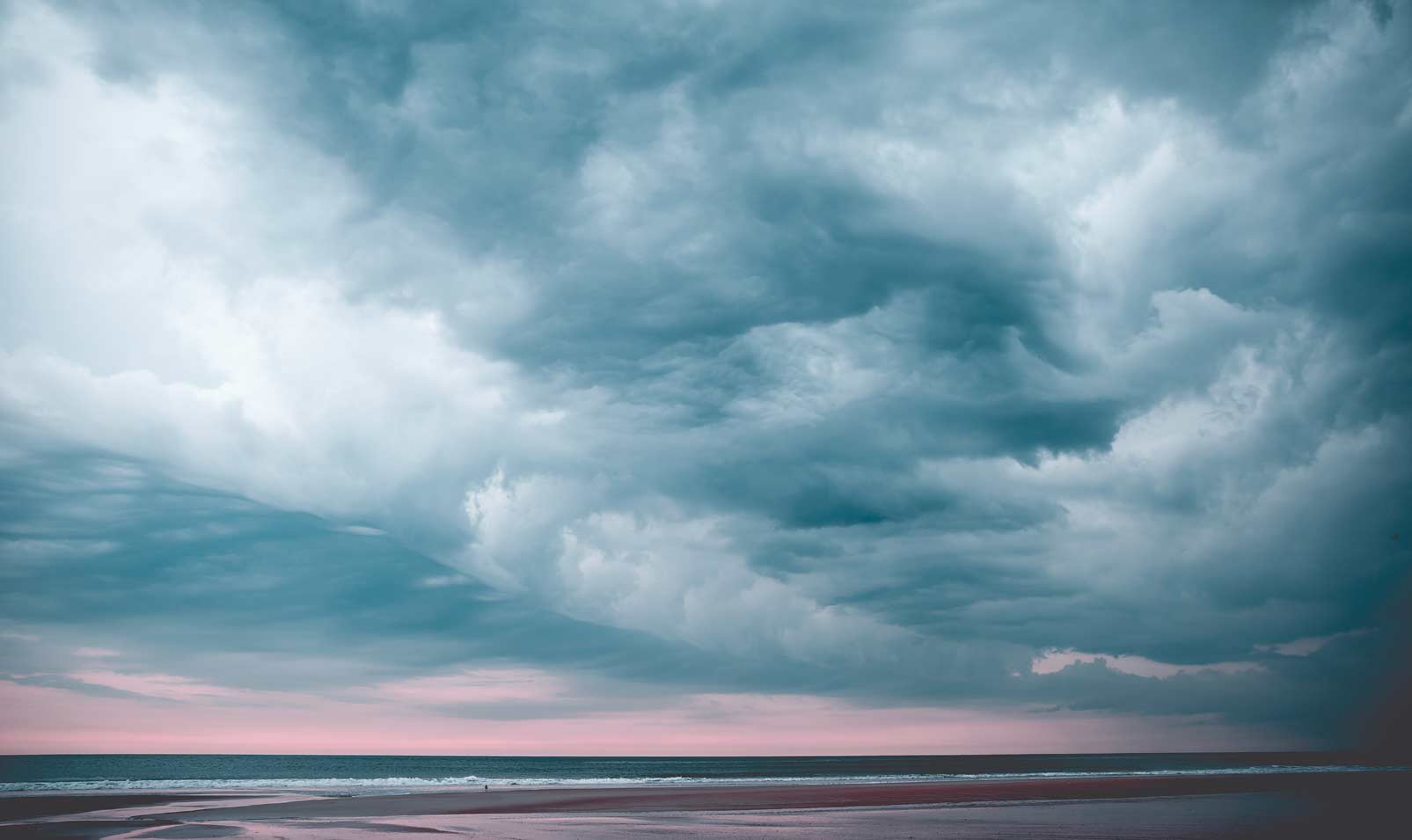
Clouds have been pondered by poets, depicted in hundreds of famous works of art, and have inspired advances in technology. They even provide us with a definition for happiness when we say we’re on “Cloud 9.”
Clouds are our constant weather predictors. And although they are part of our daily lives, there is still much we don’t know about them.
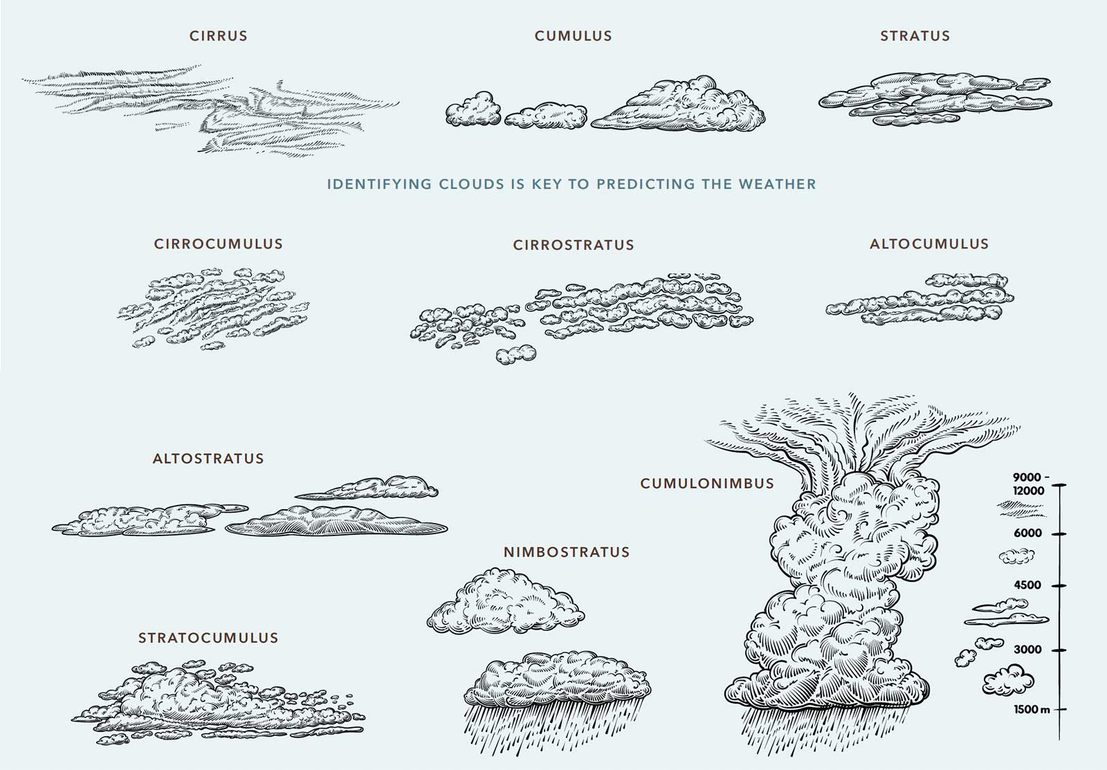
Let’s start with their names: Cloud classification hasn’t changed substantially since 1802 when Luke Howard used the Latin terms Cirrus, Cumulus, and Stratus to name the three main types of clouds. He added the Latin term Nimbus, meaning rain-bearing, and combined those terms to identify the ten main types, called “genera,” that we recognize today. The World Meteorological Organization further enhanced his classification by adding a cloud’s altitude and other information to create The International Cloud Atlas that distinguishes between genera and species of clouds and the weather they predict.
Here is your guide to cloud identification. To begin with, the three main classifications:
Cirrus: Latin for “curl of hair”
Altitude: High-level, from 5 to 15 km.
Appearance: These clouds are made of ice crystals and are thin and white with patches of visible sky in between. They are wispy and resemble stretched cotton, spider webs, or hair-like commas.
Weather: Cirrus clouds are very common; they indicate fair weather and no precipitation. An increasing cover of cirrus indicates a change of weather will occur within 24 hours.
Cumulus: Latin for “pile” or “heap”
Altitude: Low- to mid-level, from 0.2 to 2 km.
Appearance: These are the clouds we all drew as kids. They are thick, white clouds that form upwards like puffs of cotton or popcorn.
Weather: These are considered the “fair-weather” cloud, common over land on sunny days when the sun heats the land, creating thermal convection currents. Each cumulus cloud forms into a distinct shape. Cumulus clouds indicate fair weather.
Stratus: Latin for “layer” or “sheet”
Altitude: Low-level, from 0 to 2 km.
Appearance: Stratus clouds are thick, long, and uniform grey blanket clouds that sit low to the ground. They form horizontally. In the city, they often obscure the tops of buildings. They can also develop locally over forests as a result of increased humidity from the tree canopy.
Weather: If their bases reach the ground, they create fog. They can produce drizzle or light snow.
The other cloud types are variations of the three main ones:
Cirrocumulus: Latin for “wispy pile”
Altitude: High-level, from 5 to 15 km. Appearance: Cirrocumulus are thin cloud patches or flakes that look like regularly spaced cloudlets resembling grains of rice or ripples or fish scales (sometimes called a mackerel sky). They are not often visible.
Weather: These clouds are usually a transitional phase between cirrus and cirrostratus and are an indication that bad weather is approaching.
Cirrostratus: Latin for “wispy sheet” Altitude: High-level, from 6 to 13 km. Appearance: Cirrostratus clouds are very thin and look like a pale, milky lightening of the sky. Sometimes they’re so thin, they’re almost difficult to make out. They never block out the sun completely, and they can produce the optical illusion of a halo effect either around the sun or the moon.
Weather: No precipitation, but they often appear 12 to 24 hours before a rainstorm or snowstorm.
Altocumulus: Latin for “high pile”
Altitude: Mid-level, from 2 to 7 km.
Appearance: Altocumulus clouds are mostly made up of water droplets and appear as layers of grey, puffy, round, small clouds, or layers of bread rolls. Commonly seen and among the most diverse and dynamic cloud types, they are typically found in groups or clumped-together heaps.
Weather: Altocumulus clouds do not cause precipitation. However, on a warm and humid morning, they can foretell thunderstorms late in the afternoon.
Altostratus: Latin for “high sheet” Altitude:Mid-level, from 2 to 7 km.
Appearance: Altostratus can appear as sheets of featureless, grey clouds. They are called the “boring clouds” because they cover the sky and don’t have any real features.
Weather: These clouds do not impact weather significantly, although they can sometimes indicate light rain or snow.
Stratocumulus: Latin for “layer” + “pile”
Altitude: Low-level, from 0.5 to 2 km.
Appearance: These are a low puffy, grey layer forming rows in the sky. They look like cumulus clouds joined in a semi-continuous layer. They are like altocumulus, but much closer to the ground.
Weather: Stratocumulus clouds are usually an in – dication of dry weather, and precipitation is rare. Finally, let’s add “nimbus” to the mix. These are the rainy, stormy clouds that call for umbrellas:
Cumulonimbus: Latin for “pile” + “rain”
Altitude: Low- to high-level, from 0.5 to 16 km. They are so large that their base is low-level, but their tops can reach upward to high-level clouds.
Appearance: This is a vertical growing cloud that is very large and can look like a mountain or tower. The top can sometimes take the shape of an anvil or plume and its base is often quite dark.
Weather: These clouds are indicators of extreme weather, including heavy rain, hail, snow, thunderstorms, tornadoes and hurricanes.
Nimbostratus: Latin for “rain sheet”
Altitude: Low to mid-level, from 0.5 to 5.5 km.
Appearance: A dark grey, thick cloud that completely blocks out the sun. Nimbostratus are composed of water droplets, snow crystals or snowflakes, or a mixture of these, and can have a ragged base caused by the continual precipitation.
Weather: Nimbostratus clouds are associated with rainy, dreary days or snowy weather. These clouds are best known for steady and prolonged precipitation that can be moderate to heavy.
As we look up to the clouds to anticipate our weather, climatologists at NASA are looking inside clouds for the first time, using a series of specialized satellites. The project, called CloudSat, is helping scientists create detailed and accurate climate models. They hope that a closer look at cloud formations will help them predict what the surface of our planet will look like in 30 years, and how clouds could help counter global warming.
That would truly be a “silver lining.” To learn more about NASA’s CloudSat project visit: nasa.gov/cloudsat
Story by:
Micol Marotti
Photography by:
Jessica Christian